ShopDreamUp AI ArtDreamUp
Deviation Actions
![[SFM] Nature](https://images-wixmp-ed30a86b8c4ca887773594c2.wixmp.com/f/e8442548-797d-44d2-8f22-eb5080e1287c/db4fgt1-523c7e0b-7980-4d60-b48e-08253bddf972.png/v1/fit/w_375,h_211,q_70,strp/_sfm__nature_by_teluzer_db4fgt1-375w.jpg?token=eyJ0eXAiOiJKV1QiLCJhbGciOiJIUzI1NiJ9.eyJzdWIiOiJ1cm46YXBwOjdlMGQxODg5ODIyNjQzNzNhNWYwZDQxNWVhMGQyNmUwIiwiaXNzIjoidXJuOmFwcDo3ZTBkMTg4OTgyMjY0MzczYTVmMGQ0MTVlYTBkMjZlMCIsIm9iaiI6W1t7ImhlaWdodCI6Ijw9NTc2IiwicGF0aCI6IlwvZlwvZTg0NDI1NDgtNzk3ZC00NGQyLThmMjItZWI1MDgwZTEyODdjXC9kYjRmZ3QxLTUyM2M3ZTBiLTc5ODAtNGQ2MC1iNDhlLTA4MjUzYmRkZjk3Mi5wbmciLCJ3aWR0aCI6Ijw9MTAyNCJ9XV0sImF1ZCI6WyJ1cm46c2VydmljZTppbWFnZS5vcGVyYXRpb25zIl19.wO6S7DAU7FBygjgL0ejYEPHY5BDJ--9vLnRYrR8SWVQ)


Suggested Deviants


Suggested Collections


![Map of Equestria [MLP:FIM]](https://images-wixmp-ed30a86b8c4ca887773594c2.wixmp.com/f/02df190a-e347-48d5-80d8-5b09adb9f431/d4czwjj-68803fd0-ce53-4def-b93a-f92070112ef3.png/v1/crop/w_184,h_184,x_15,y_0,scl_0.061333333333333/map_of_equestria__mlp_fim__by_djinn327_d4czwjj-92s-2x.png?token=eyJ0eXAiOiJKV1QiLCJhbGciOiJIUzI1NiJ9.eyJzdWIiOiJ1cm46YXBwOjdlMGQxODg5ODIyNjQzNzNhNWYwZDQxNWVhMGQyNmUwIiwiaXNzIjoidXJuOmFwcDo3ZTBkMTg4OTgyMjY0MzczYTVmMGQ0MTVlYTBkMjZlMCIsIm9iaiI6W1t7ImhlaWdodCI6Ijw9MzAwMCIsInBhdGgiOiJcL2ZcLzAyZGYxOTBhLWUzNDctNDhkNS04MGQ4LTViMDlhZGI5ZjQzMVwvZDRjendqai02ODgwM2ZkMC1jZTUzLTRkZWYtYjkzYS1mOTIwNzAxMTJlZjMucG5nIiwid2lkdGgiOiI8PTM5NTAifV1dLCJhdWQiOlsidXJuOnNlcnZpY2U6aW1hZ2Uub3BlcmF0aW9ucyJdfQ.a8XptSBM67jW_bkjTMbq5g0-86gJKeozZQdUcbHpCfw)
![Map of Equestria [MLP:FIM]](https://images-wixmp-ed30a86b8c4ca887773594c2.wixmp.com/f/02df190a-e347-48d5-80d8-5b09adb9f431/d4czwjj-68803fd0-ce53-4def-b93a-f92070112ef3.png/v1/crop/w_92,h_92,x_7,y_0,scl_0.030666666666667/map_of_equestria__mlp_fim__by_djinn327_d4czwjj-92s.png?token=eyJ0eXAiOiJKV1QiLCJhbGciOiJIUzI1NiJ9.eyJzdWIiOiJ1cm46YXBwOjdlMGQxODg5ODIyNjQzNzNhNWYwZDQxNWVhMGQyNmUwIiwiaXNzIjoidXJuOmFwcDo3ZTBkMTg4OTgyMjY0MzczYTVmMGQ0MTVlYTBkMjZlMCIsIm9iaiI6W1t7ImhlaWdodCI6Ijw9MzAwMCIsInBhdGgiOiJcL2ZcLzAyZGYxOTBhLWUzNDctNDhkNS04MGQ4LTViMDlhZGI5ZjQzMVwvZDRjendqai02ODgwM2ZkMC1jZTUzLTRkZWYtYjkzYS1mOTIwNzAxMTJlZjMucG5nIiwid2lkdGgiOiI8PTM5NTAifV1dLCJhdWQiOlsidXJuOnNlcnZpY2U6aW1hZ2Uub3BlcmF0aW9ucyJdfQ.a8XptSBM67jW_bkjTMbq5g0-86gJKeozZQdUcbHpCfw)


You Might Like…


Description
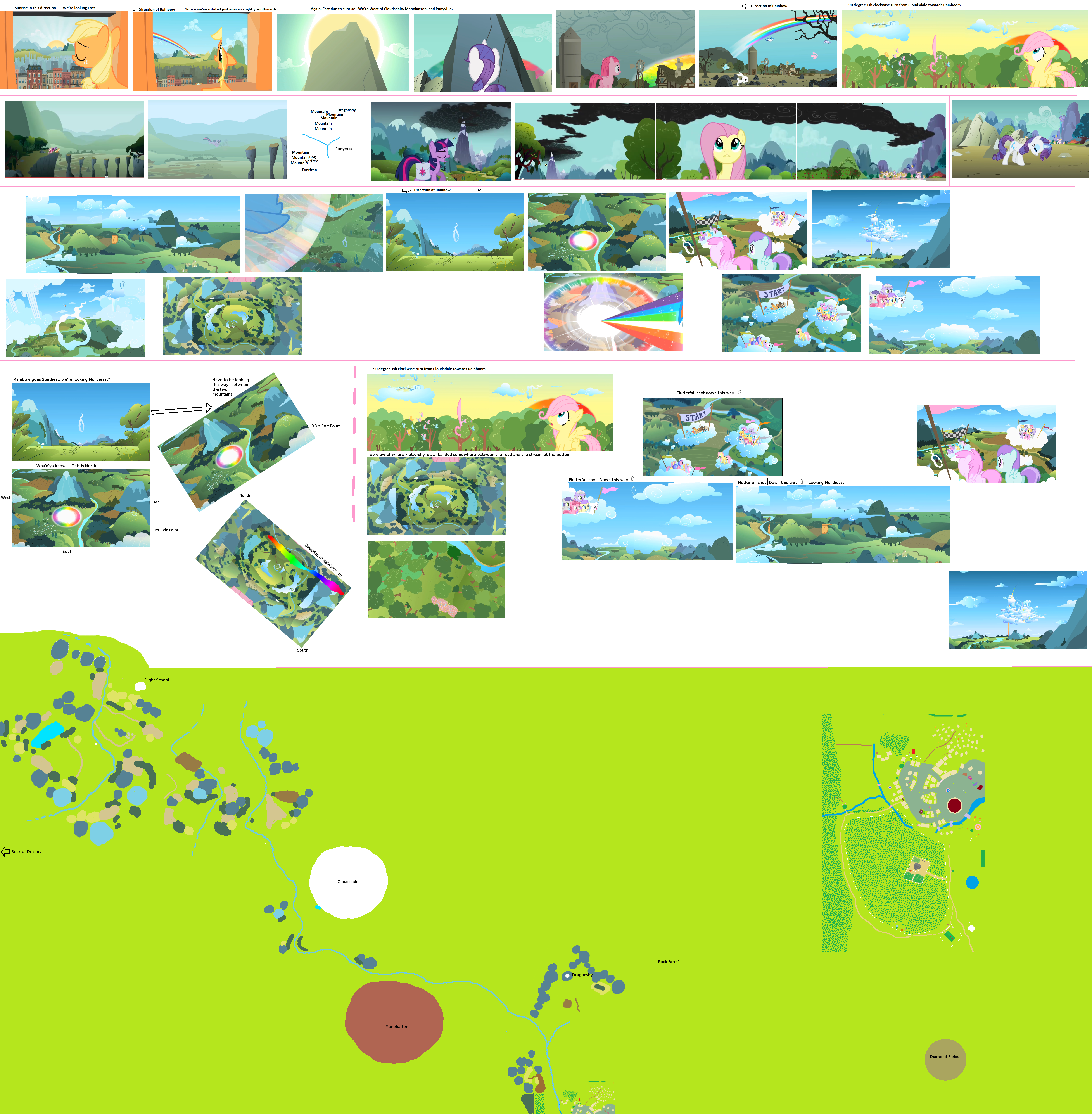
Due to a few encounters over the past couple of months, I've realized that it might be best to present the exact logic I use to try and make these maps in addition to just providing a bunch of reference shots. I know for a fact that I make mistakes. Heck, that's why I'm still going back through the first season instead of moving on to season two. I guess I just have a feeling that if I have to properly explain why I think certain places go where they go, then there's a better chance I'll actually get it right. Plus, if you believe I got it wrong, this provides y'all with all of my reasoning and a place to present your alternate theories. If you can back your ideas up with solid facts, I want to hear them ASAP, because the sooner the map is fixed, the less folks end up using a map with errors. And that's all that this project is about - creating the most accurate map of Ponyville and its surroundings. I could care less about my pride. Here's hoping y'all take me seriously on that.
-------------------------------------------------
But in any case, let's get on to the main attraction! We're going to attempt to locate Cloudsdale through the Sonic Rainboom along with as many other places as we can pull off. I'd like to draw your attention to the first bracket of the image.
First things first, we need to figure out the direction RD was headed right after the Rainboom. We know for a fact that the rainbow started in the general vicinity of Cloudsdale. Also, due to AJ's story we know that the rainbow crossed over Ponyville at some point. So let's look at AJ's perspective right quick. Since the sun is just rising, we can surmise that we are looking East (that is, if the sun isn't in a random direction again). The next shot is right as the rainbow reaches Ponyville. Notice that the mountains have rotated slightly, and our perspective is a bit further south (SE-E?). This places Manehatten to the NW-W of Ponyville. The sheer number of mountains between / to the north of these two towns also supports this direction as the vast majority of mountains are located to the north of Ponyville. Plus, despite the fact we're definitely to the West of Ponyville, we can't really see the Everfree (which only stretches part of the way up the height of Ponyville), further locating us northwards.
As a plus, we can locate Cloudsdale based on this perspective! Since the rainbow has a slightly southern tilt and we're already looking SE-E, that should make RD's path spot on SE. Ergo, Cloudsdale is to the NW of Ponyville. We don't have an exact location yet, but we can work on that in a moment.
Our next target is Rarity's Rock of Destiny. Again, the sun is arising to the East (hopefully), and this is also the exact direction that the rainboom comes from. With any luck, this means that the Rock of Destiny should be to the West of Cloudsdale, and thus NW of Ponyville. This also fits with Rarity's very circuitous journey that took her all night. After all, she first went South towards Appleloosa (going left, setting sun in the background, it's south-ish), then circled around to who knows where for about twelve to sixteen hours. Why not way up North?
Next puzzle - where is the Rock Farm? After the Rainboom, we can see the rainbow is heading to the left, the exact opposite direction it was heading for AJ. Assuming that we're seeing the same rainbow, that means we have to be somewhere on the opposite side of the line, possibly mirrored. Assuming the same distance-ish, this puts us somewhere to the North of Ponyville, right smack dab in the middle of the giant mountain range, perfect for a rock farm.
Now comes the "fun" part - getting the exact location of Cloudsdale. First things first, we need to look at what is already known to be to the Northwest of Ponyville, specifically Mount Dragonshy and Froggy Bottom Bog. Let's look at the second row. First things first: Mount Dragonshy. Based on the perspective in the Fluttershy shot and the variety of other places that make it into the panorama, we can see that Dragonshy is definitely on the western side of the mountain range to the north. Also, since it's a bit faded compared to other shots and even the other mountains, that means it should be farther north than the main mountain range (i.e. it's too far south on the current map). However, this means that the Twilight shot is somehow missing a lot of the trees and houses in Ponyville that are confirmed multiple times to be in that general direction that should be blocking the view. Assumedly they were removed the shot for dramatic effect (?), but it's still a bit of nuisance as it means we can't really get any exact directional data from the shot. Nothing to reference to. But assuming that this is the view that we would be seeing from behind the library if you were to look NNWish (with nothing in the way), we have a general idea of the farmlands and mountains in that direction.
Now let's combine this with the Froggy Bottom Bog and Manehatten shots. Manehatten says that there should be a valley between a giant range of mountains and a smaller clump of mountains. Bog says that there should be a small batch of hills/mountains on the northern tip of the Everfree. Possibly the same small clump in both cases. Also, Manehatten says that it cannot see Dragonshy from that window, placing it further still to the north, and that it cannot see the Everfree, placing it to the south... or behind the small clump of mountains. Since we know that the valley probably shouldn't be too "big" relatively speaking, we know that each of these missing items should probably be just out of view. Combine that with the mini mountain range looking an awful lot like hills on the left side of the first bog shot, and we have a really strong chance of localizing the bog. Heck, I wouldn't be surprised if the hill the girls jumped to was the light green mountain in the second Manehatten shot. As for Mount Dragonshy, we'll just have to assume it's so far north it's out of the shot (unlikely due to scale near Ponyville), or it's hidden behind those really tall mountains on the left side of the first Manehatten shot. Either way, Dragonshy is way too far south on the map.
(With regards to the Rarity shot sitting in its own segment, I figured it would be as good a time as any to place the Diamond Dog fields. As you can see, we can spot Canterlot, Ponyville, and that giant hill in the middle of SAA all in the background. Needless to say, we're to the south of Ponyville. How far south I couldn't say, but it's got to be a good ways past the southern tip of the Acres. After all, the landscape has to have time to completely change. Not to mention the SAA hill is pretty dang tiny. And yes, sadly, this is the only screenshot that even hints at the diamond field's location (other than Spike running into town from a south-eastern bridge).
Now that we have the surrounding area refigured out, time to get the exact details of the area around Cloudsdale. Look at sections 3 and 4. 3 contains a bunch of photos from the episode that are displayed in order on the top row, and a handful of related shots in the row below it (both from the RD segment and from Fluttershy's segment). Section 4 is my notes and piecemeal placement. Primarily we'll be focusing on 4.
We now know that there is a massive mountain range north of Ponyville, and we can also see that the mountains sort of end before reaching Manehatten's horizontal position. Since we know that Cloudsdale is NW of Ponyville (and unknown amounts of north/west from Manehatten), our best bet is to find what looks like our massive mountain range somewhere in the distance of a Cloudsdale shot. (By the way, if you're wondering why we're only using shots from Cutie Mark Chronicles, it's because there are no useful shots from Sonic Rainboom. Actually... there's one, but there's not enough context to make it useful.) Looking at all of the screenshots, there's really only one shot that looks even remotely like the kind of mountains we want to see, the sideways shot where RD is about to pull a 90 degree turn and a Sonic Rainboom. Unfortunately, because we know the rainbow is going southeastish, we have to be looking northeast. Wrong way for Ponyville, but it does prove that there are a heck of a lot of mountains to the north! In case, we can use this shot now to figure out where the training grounds are exactly located since RD's rainboom was a decent distance from them. Just have to follow the pictures back to the beginning. Let's line up the next shot in chronological order so that the mountains and such are facing in about the same direction as they were in the first image. (Why yes I did finally discover how to properly use GIMP. Thanks for asking!) We know for a fact it's the same area due to chronological order. We also know that this is pretty much the only possible orientation that makes sense for a variety of reasons. The rainbow was a straight on shot in the first pic, and a 45 degree rotation in the next. Change the mental orientation in the second pic and voila, we know what mountains are visible on the left in the first shot. All the hilly farmland/mountains and such in the first background are rather far off in the distance, and thus can't be seen in the second shot. In any case, now that we have a general idea of the area surrounding the rainboom from a top down perspective, let's finagle our way back to the training grounds.
Our next best bet is to look at Fluttershy's scenario. We get a massive view of the ground below plus a shot of both the training grounds and the rainboom at the exact same time. Looking at the upper shot in context, we can see that the rainboom and the training grounds are about 80-90 degrees off from each other (based on time differential) at Fluttershy's position right below the starting point of the race course. Unfortunately, due to all the trees we can't tell which way we're looking... However, if we can figure out where the race start is in comparison to the training grounds however, we're golden.
Now here's where it get's tricky... On the off chance you haven't noticed before, there will never be a 100% connection rate between two different backdrops. Ever. And that's doubly true when it comes to landscaping like trees, mountains, and rivers. Best you can hope for is that they'll keep the same major types of features in the same general areas despite scrambling the actual appearance drastically. tl;dr - I'm going to be grabbing rivers that flow ever so slightly differently and claiming they're the same river. Why? Because it's logically the same river due to placement in the previous scene. You'll see what I mean in a moment. (Also, everything past this point is definitely stream of conscience, written on the fly as I discovered each orientation)
First shot, the Flutterfall. Great giant layout shot, and directly below the starting point. We know for a fact that Fluttershy lands right next to the stream. But which part? The copious amount of trees in the closeup shot (with the butterflies) doesn't fit with *any* part of the large zoomed out shot. We'll have to assume that they just didn't draw them all... Since this only partially narrows our fall location to a small stretch of land, let's look at the next pair of shots featuring the starting line. The top view shows a stream with two roads on either side of it. There are also hills, but they aren't helpful due to the Flutterfall shot blending them out/lack of detail. So, let's take our road-stream-road connection and attempt to find a match. Since the stream takes a 90 degree turn at one point, we have two possible places this could match, at the bottom and on the left side. Looking at the left side, we can see a huge amount of space on both sides of the stream, but, unfortunately, this means that we can only see one road running parallel to the water with no chance of another road on the other side. That only leaves the bottom side. Luckily, the stream is positioned so close to the edge of the shot that we can "imagine" the second road just out of view, thereby giving us our location. We're right over the bottom stream and the upper starting line shot is oriented as specified. Moving to the lower starting line shot, we know that the shot has to have the specified orientation because of the cloud with the little kiddos. Also, because of the sheer number of similarities between the two (position of the creek, lots of identical trees, that odd little squiggly strip of green, etc.), we know that the long race shot just right of the lower starting line shot is looking at the exact same terrain, although at a slightly lower perspective and level of detail in places. Thus, same orientation. Analyzation of these two shots from this perspective work perfectly with the known terrain as there are no conflicts. If anything, it just gives us more terrain to work off of. We now know the creek had to make a right angle turn shortly after the Flutterfall shot (hinted at in Flutterfall actually as well), we have a good idea about some of the mountains, we know where a very small town is located at, and we know where a few more roads are at. Even better we now know which direction the rainboom is at! Remember, our two racers are pretty much just diving straight down from this point, meaning their orientation from this location should stay practically the same. In other words, they're currently headed left and parallelish to the lower stream in the flutterfall shot, and since this direction of travel is southeast, up in flutterfall is southwest and down is northeast! I'll let y'all make the other directional realizations in other shots on your own. In any case, now we just need to confirm the locale of the rainboom in relation to flutterfall, or at least make sure that there aren't any major clashes. Based on the flow of the streams in both images (use the direction of rainbow shot back on the far left combined with the rainboom shot), the obvious placement of the rainboom would be right at the right angle crook of the stream. However, this does not even come close to matching up with the mountains... So, let's keep following the trail. The dive would have actually started somewhere in the range of the right angle turn in the flutterfall creek anyways, so we need to keep going forward a bit. So... what if this is actually yet another creek, positioned just out of view to the east/north of the flutterfall shot? We snag a mountain from the eastern corner of flutterfall, that road on the right side of the long race shot, and then match them up with their equivalents on the western side of the rainboom shot. Combine those pieces together, and *wham!*, we've got our rainboom. Looks like Fluttershy is to the northwest of the rainboom! Now we can use the 90 degree rotation from before! This places the flight academy (not Cloudsdale) to the northeast of Fluttershy, and quite probably north of the rainboom. From the rainboom we can follow RD to continue upwards through the finish line, over Cloudsdale, back down, and then level out to keep on trucking towards Ponyville and who knows where after that. Using the remaining two screen shots, we can add on the remaining terrain. Looks like there's yet another stream mountain pair... And it also looks like we're not going to be able to get the exact distance from Cloudsdale to Ponyville... But we can recreate the landscape under Cloudsdale! Unless... two more possible coincidences. First off, look at the mountains in the distance of the ground version of the Rainboom shot (top left of section 4). Now look at the clump of mountains in the background right behind the finish line. Look familiar? In one shot we're looking NE, the other NW. Perfect combo. We have the distance from Cloudsdale to the flight academy. Next coincidence: I want y'all to go back to the AJ shots at the very top. Zoom in to at least 100% of the original size, even bigger if you can swing it. Look at the right/second pic. Now take a very good look at that river that we know for a fact surrounds Ponyville... Hope you can see it, but not only does the river circle around the town, but it splits off and heads NW, more than likely connecting with one of the rivers we've seen before just a bit before. Next thing you need to notice is in the first/left AJ pic. Notice the extremely tall mountains on the far left. Also notice the large amount of tree cover in this direction in front of the mountain. Now scroll all the way down to the bottom right corner to look at Cloudsdale. I don't know about the rest of y'all, but I'm seeing a river, some taller than average mountains to the right (bigger than the little one at the base and possibly as tall as Cloudsale. Shouldn't that be big enough to disguise Mount Dragonshy?), and quite a few lines of trees right in front of some hills to the left. I don't know about the rest of y'all, but that's good enough for me. Better than anything else we have to go on anyways. So, time to move on to the final step - the actual mapping. You can find the results down at the bottom.
And of course the actual mapping screws up part of those coincidences if we want to keep the straight SE line. I popped in a cloud right about where the starting point was, and another where the rainboom was at. From there, a straight line puts the lie to those mountains in the Cloudsdale shot being anywhere near Ponyville. Sorta sad... In any case, using the rainbow line, the view required by the AJ scene, the possible sizes of the towns (although there's a decent chance they're even bigger), and the mandatory river (assuming it's the same river?), we can triangulate a general idea of where everything is at. No idea how accurate it is in terms of scale, but it's probably very close. Also, the vast majority of those mountains near Ponyville? They should be accurate now.
As for the odd side map thing to the right? That's primarily to give a general sense of where the Diamond Dog Fields are at. And to give a bit of a preview of some of what's been done so far in Ponyville proper. Still a ways to go.
-----------------------------
In any case, I know I promised y'all that I'd be done with the Season 1 edits today, but there's no possible way that's going to happen sadly. Family finally has me to themselves for the first time in months and they know I have nothing that's "required" to be done by their standards. Combine that with this writeup, a lot of extra snapshot taking both for this scene and a few other complicated locations, and well... tl;dr - I don't think I'll be caught up by Christmas. Still, here's hoping this helps y'all out a bit and that it'll tide you over for now. I'm thinking of doing more of these explanations in the future actually. Surprisingly helps a lot to get your thoughts down on "paper". Plus, it'll be good to have if I ever need to come back and re-edit a section. Let me know what you think, and *please* do your best to find holes in my logic. Like I said at the top, my goal is to get these maps to be the most accurate and complete maps anypony can find of Ponyville and I guess all of Equestria now. There's no possible way I'll be pulling off street guides for Canterlot and the like (at least not for a good long while), but it's still good to get the lay of the land around them. See ya' on the flip side!
Image size
5000x5100px 7.2 MB
© 2011 - 2024 Aurek-Skyclimber
Comments9
Join the community to add your comment. Already a deviant? Log In
Anyone else going to point out the animation error on the second AJ pic? No? K